
Introduction
Satellites help us communicate, watch television, study weather, and access information from distant places. Many of these services depend on spacecraft moving around Earth in carefully planned paths. One special path is called a geostationary orbit. It allows a satellite to appear almost motionless above the same location on Earth.
This may sound surprising because satellites are always moving. However, a geostationary satellite travels at a speed and altitude that match Earth’s rotation. As our planet turns, the satellite moves in the same direction and at the same angular rate. This makes its position appear fixed to people on the ground.
Geostationary satellites are useful for television broadcasting, weather observation, and long-distance communication. They can monitor the same region throughout the day and maintain stable links with ground stations. However, they also have limits, including signal delays and weaker coverage near the poles.
Understanding this orbit helps explain how modern space technology works. It also introduces important ideas about gravity, orbital speed, and Earth’s rotation. This guide explains these concepts in simple language, with practical examples and useful comparisons.
What Is a Geostationary Orbit?
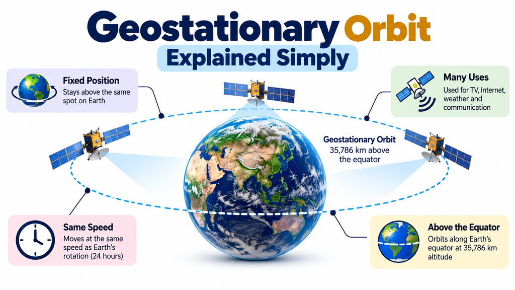
A geostationary orbit is a circular path around Earth where a satellite appears to stay above the same point on the ground. The satellite travels above the equator and moves in the same direction as Earth’s rotation.
The word geostationary combines the ideas of Earth and a stationary position. However, the satellite does not stop moving. It continues to travel around Earth while maintaining a matching rotational rate.
A true geostationary orbit has three main features:
- Circular shape: The satellite maintains a nearly constant distance from Earth’s centre.
- Equatorial position: Its orbital path lies directly above Earth’s equator.
- Matching orbital period: It completes one orbit in about 23 hours, 56 minutes, and 4 seconds.
This period is known as a sidereal day. It measures Earth’s rotation relative to distant stars and is slightly shorter than a 24-hour solar day.
These conditions allow the satellite to appear fixed in the sky. For example, a satellite dish can point toward a geostationary satellite without continually tracking its movement.
The European Space Agency (ESA) explains that geostationary satellites are especially useful for communication and weather monitoring because they remain above the same region. This makes them valuable for services that need continuous coverage.
How Does a Geostationary Orbit Work?
A geostationary orbit depends on gravity, orbital speed, and Earth’s rotation. These factors work together to keep a satellite moving around Earth in a predictable path.
Earth’s gravity pulls the satellite toward the planet. At the same time, the satellite moves forward at a high speed. Instead of falling directly toward the surface, it continues moving around Earth. This continuous motion creates an orbit.
The satellite’s altitude determines how long it takes to complete one orbit. Satellites closer to Earth travel around the planet more quickly. Satellites farther away take longer to complete an orbit.
A geostationary satellite must reach the correct altitude for its orbital period to match Earth’s sidereal rotation period. It must also travel in the same direction as Earth rotates.
Imagine watching a person walk around the centre of a rotating platform. If the platform and the person complete each rotation in the same time and direction, their relative positions can remain aligned. A geostationary satellite follows a similar principle, although gravity governs its actual orbital motion.
The satellite travels at roughly 3.07 kilometres per second. It appears stationary because its angular motion matches Earth’s rotation. Its speed is essential because a satellite at the wrong altitude or speed would not remain above the same point.
How High Is a Geostationary Orbit?
A geostationary orbit is approximately 35,786 kilometres above Earth’s mean sea level. This is much higher than the orbits used by many Earth observation satellites and crewed spacecraft.
It is important to understand the difference between altitude and orbital radius. Altitude measures the distance above Earth’s surface. Orbital radius measures the distance between the satellite and Earth’s centre.
For a typical geostationary orbit, the orbital radius is about 42,164 kilometres. This includes Earth’s mean radius of approximately 6,378 kilometres.
This specific altitude allows the satellite to match Earth’s rotational period. At a lower altitude, the satellite would complete its orbit more quickly. It would then appear to move across the sky relative to an observer on Earth.
The high altitude also provides a wide view of the planet. A single geostationary satellite can serve a large region, depending on its position, antenna design, and signal coverage. However, Earth’s curvature prevents it from seeing every location.
The distance also creates a disadvantage. Radio signals must travel a long path between the satellite and ground stations. This adds delay to communication services, especially when signals must travel up to the satellite and back down.
Why Does a Satellite Appear Stationary?
A geostationary satellite appears stationary because it maintains nearly the same position in the sky for an observer on Earth. Its orbit matches Earth’s rotation in both direction and angular rate.
Imagine a weather satellite positioned above the equator near a particular longitude. An observer within its coverage area can see it in roughly the same direction throughout the day.
This stable position is especially useful for communication systems. A ground antenna can point toward the satellite without constantly changing direction. The satellite can then relay signals between distant ground stations.
However, the satellite is not stationary relative to space. It continuously travels around Earth. Its apparent fixed position results from the relationship between its orbital motion and Earth’s rotation.
In practice, small changes in its orbit can occur because of gravitational effects from the Moon and Sun, along with variations in Earth’s gravitational field. Satellite operators use station-keeping manoeuvres to keep the spacecraft near its assigned position.
This process helps maintain reliable communication links and keeps the satellite within its planned orbital location.
Geostationary Orbit vs. Geosynchronous Orbit
Geostationary and geosynchronous orbits are closely related, but they are not identical.
A geosynchronous orbit has an orbital period equal to Earth’s sidereal rotation period. However, the satellite’s orbital shape or inclination may differ from the conditions required for a geostationary orbit.
A geostationary orbit is a special type of geosynchronous orbit. It must be circular, lie above the equator, and follow Earth’s rotation.
| Feature | Geostationary Orbit | Geosynchronous Orbit |
|---|---|---|
| Orbital period | One sidereal day | One sidereal day |
| Orbit shape | Circular | May be circular or elliptical |
| Orbital inclination | Zero degrees | May be tilted |
| Apparent position | Nearly fixed | May move across the sky |
| Ground track | Fixed point above the equator | May form a repeating loop |
| Common applications | Communication and weather monitoring | Communication and other satellite missions |
For example, a tilted geosynchronous satellite may appear to move north and south during the day. An elliptical geosynchronous satellite may also appear to move east and west.
A geostationary satellite avoids these apparent movements because it meets the required orbital conditions. This difference matters when choosing an orbit for a particular satellite service.
Main Uses of Geostationary Satellites
Geostationary satellites are useful when a service needs a stable view of a region or a continuous communication link. Their high altitude allows them to cover large areas without frequently changing their apparent position.
Television Broadcasting
Television broadcasters use geostationary satellites to distribute programmes across large regions. A ground station sends a signal to the satellite, which then transmits it back to receivers within its coverage area.
For example, a broadcaster can send the same programme to many homes across a country. Satellite dishes can receive the signal while remaining pointed in one direction.
Satellite Communication
Communication satellites help connect locations that are far apart or difficult to reach with cables. They can relay voice calls, data, and other signals between ground stations.
These services may support ships, aircraft, remote facilities, and communication networks. Their performance depends on the satellite equipment, ground infrastructure, and available coverage.
Weather Monitoring
Weather satellites in geostationary orbit repeatedly observe the same broad region. This helps meteorologists track cloud movement, storms, and changing weather patterns.
For example, repeated satellite images can show how a storm develops over an ocean. This information supports weather analysis and forecasting.
However, geostationary satellites do not replace every other type of weather satellite. Lower-orbit spacecraft can provide more detailed observations of certain features.
Internet Connectivity in Remote Areas
Some satellite internet services use geostationary satellites to connect areas with limited access to ground networks. These services can help remote communities, rural businesses, and isolated facilities access online resources.
The main limitation is signal delay. The long distance between Earth and the satellite can affect video calls, online gaming, and other activities that require quick responses.
Emergency Communication
Natural disasters can damage mobile towers, power systems, and communication cables. Satellite links can provide an alternative when ground networks are unavailable.
Emergency teams may use satellite communication to share information and coordinate their work. Geostationary satellites are useful when stable communication is needed across a large region.
Data Relay and Space Operations
Some geostationary satellites relay information between spacecraft and ground stations. These systems can help other spacecraft transmit data when direct communication with a ground station is not available.
This is useful for certain space missions that need frequent data transfers. The exact role depends on the satellite system and the mission requirements.
Advantages of Geostationary Orbit
Geostationary orbit offers several benefits for communication and observation missions.
- Wide-area coverage: A satellite can serve a large portion of Earth’s visible surface.
- Continuous observation: Weather satellites can monitor the same region repeatedly throughout the day.
- Fixed ground antennas: Satellite dishes can point in one direction instead of tracking a moving spacecraft.
- Stable communication links: A satellite can maintain long-term connections with suitable ground stations.
- Efficient broadcasting: One satellite can distribute the same signal to many receivers.
- Support for remote areas: Satellite services can reach places where ground infrastructure is difficult to build.
These benefits make geostationary orbit particularly useful for broadcasting and continuous regional monitoring. Still, the best orbit depends on the mission’s needs.
Limitations of Geostationary Orbit
Despite its benefits, geostationary orbit is not suitable for every satellite mission. Its high altitude creates several technical and practical challenges.
- Signal delay: Signals travel a long distance between Earth and the satellite, which can slow interactive services.
- Limited polar coverage: Areas near the North and South Poles are difficult to serve because the satellite sits above the equator.
- High deployment costs: Reaching geostationary orbit requires significant launch energy and careful manoeuvres.
- Signal loss: Signals weaken over long distances, so systems need suitable antennas and power levels.
- Orbital maintenance: Operators must monitor the satellite and make corrections when necessary.
- Space environment: Radiation and other conditions can affect satellite electronics.
- Orbital coordination: Satellite operators must coordinate positions and frequencies to reduce interference and manage collision risks.
These limitations explain why engineers choose different orbits for different tasks. A mission that needs low communication delay may benefit from a lower orbit.
Geostationary Orbit vs. Low Earth Orbit
Low Earth orbit, often called LEO, is much closer to Earth than geostationary orbit. It generally includes altitudes below 2,000 kilometres, although individual satellites operate at different heights within that range.
Satellites in LEO move quickly around Earth. Many complete an orbit in roughly 90 minutes, depending on altitude. Because they move across the sky, a communication network may need multiple satellites to provide continuous coverage.
Geostationary satellites work differently. Their high altitude allows them to remain above the same point on the equator. This makes them useful for continuous regional communication and weather observation.
| Feature | Geostationary Orbit (GEO) | Low Earth Orbit (LEO) |
|---|---|---|
| Typical altitude | 35,786 km | Below 2,000 km |
| Orbital period | About 23 hours, 56 minutes | Often around 90 minutes |
| Apparent movement | Nearly fixed over one point | Moves across the sky |
| Coverage per satellite | Very broad | Smaller area at one time |
| Signal delay | Relatively high | Generally lower |
| Antenna requirements | Fixed antennas are often possible | Tracking or satellite handovers may be needed |
| Common applications | Broadcasting, communication, weather monitoring | Earth observation, crewed missions, many satellite internet systems |
Neither orbit is always better. The right choice depends on coverage, signal delay, observation detail, cost, and mission objectives.
Common Misconceptions About Geostationary Orbits
Several misunderstandings can make this topic confusing. These points explain the facts clearly.
- The satellite does not move: It moves continuously around Earth but appears stationary from the ground.
- Gravity does not affect the satellite: Earth’s gravity keeps the satellite in its orbital path.
- Every geosynchronous satellite is geostationary: Geosynchronous satellites may have tilted or elliptical orbits.
- One satellite can see the entire planet: Earth’s curvature blocks parts of the surface, especially near the poles.
- Geostationary orbit is best for every mission: Lower orbits may be better for shorter signal delays or detailed surface observations.
- Satellites never need adjustments: Operators may need to correct small orbital changes to maintain the planned position.
Understanding these differences helps readers learn how satellite systems work and why engineers choose particular orbits.
Important Considerations
Several practical factors matter when operating or studying a geostationary satellite system.
- Orbital position: The satellite must remain close to its assigned location to provide reliable service.
- Visibility from the ground: Buildings, mountains, and other obstacles can block the line of sight.
- Signal delay: The long signal path affects interactive services and must be considered during system design.
- Coverage area: Coverage depends on the satellite’s location, antenna design, and the region it can see.
- Space debris: Operators must manage collision risks and plan safe disposal after a satellite’s working life.
- Power and equipment: Satellites need reliable power systems, antennas, and electronics to operate in space.
- Mission requirements: Engineers must compare different orbits before selecting the best option.
These factors help balance performance, cost, coverage, and safety. They also show why satellite design involves more than choosing an altitude.
Frequently Asked Questions
1. What is a geostationary orbit in simple words?
It is a circular orbit above Earth’s equator where a satellite appears to stay above the same point on the ground.
2. How high is a geostationary satellite?
It orbits approximately 35,786 kilometres above Earth’s mean surface. Its orbital radius from Earth’s centre is about 42,164 kilometres.
3. Why does a geostationary satellite appear stationary?
Its orbital period matches Earth’s sidereal rotation period. It also moves in the same direction and follows a circular equatorial path.
4. How long does a geostationary satellite take to orbit Earth?
It takes about 23 hours, 56 minutes, and 4 seconds. This is one sidereal day, which is slightly shorter than a 24-hour solar day.
5. What is the difference between geostationary and geosynchronous orbit?
A geosynchronous orbit has the same period as Earth’s sidereal rotation. A geostationary orbit is circular and equatorial, allowing the satellite to appear fixed above one location.
6. Why are geostationary satellites placed above the equator?
An equatorial orbit allows the satellite to match Earth’s rotation without appearing to move north or south. A tilted orbit would create visible movement in the sky.
7. What are geostationary satellites used for?
They support television broadcasting, communication, weather monitoring, data relay, and some internet services.
8. Can geostationary satellites provide internet access?
Yes. They can provide internet access to remote locations. However, their long signal paths create more delay than many lower-orbit systems.
9. Why do geostationary satellites have signal delays?
Signals travel a long distance between Earth and the satellite. The delay increases when information must travel up to the satellite and back down to another ground station.
10. Can a geostationary satellite cover the entire Earth?
No. A single satellite can see a large region, but Earth’s curvature blocks some areas. Polar regions are particularly difficult to cover from geostationary orbit.
Conclusion
Geostationary orbit is an important part of modern satellite technology. It allows a satellite to appear fixed above one point on Earth’s equator. This happens because the satellite’s orbital period matches Earth’s rotation relative to distant stars. Its altitude of approximately 35,786 kilometres makes this matching motion possible.
Geostationary satellites support television broadcasting, communication, weather monitoring, and data relay. Their wide coverage and stable apparent position make them useful for services that need continuous connections. However, their high altitude also creates challenges. Signal delays, limited polar coverage, launch costs, and orbital management must all be considered.
Geostationary orbit is not the right choice for every mission. Low Earth orbit may be better when shorter signal delays or detailed observations are important. Understanding these differences helps explain why spacecraft use different paths around our planet.
Readers interested in aviation technology and related technical topics can also explore astropilot.co. Learning about satellites and orbital mechanics provides useful context for understanding the wider technologies that support communication, navigation, and modern transport.